Thus week's Sepia Saturday propmpt photograph shows two women together, perhaops mother and daughter and is that a birthday cake by their side? I had a trawl thriough my family collection to show lives in twosomes.

My huisband's grandparents, Alice Armitage and Matthews Iley White of South Shields, County Durham, England - this is believed to be their engagement photograph. They married in 1906.

An elegant wedding photograph of my cousin's Oldham relations - Sarah Alice Oldham on her wedding to George Butler in Blackpool, Lancashire and what a showy outfit - magnificently decorated large hat, stylish dress with frills and a large posy set off by long broad ribbons! Sarah came from a local family of carters and coal merchants down three generations and George also worked in the business. Date 1907.

My grest aunt Jennie Danson of Poultonb le Fylde, Lancahsire married Bill Stemp in 1928 - there is no mistaking that period with her cloche hat and style of dress.
Family LIfe

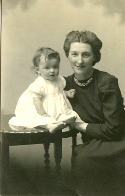
From my cousin's collection - charming picture of Ellen Florence
Coombs nee Hooker with her baby daughter Hilda
Florence.

One
of the oldest photograph in my collection shows, on the left, my aunt
Edith and on the right my mother Kathleen - taken late 1908. The
sisters were
born one year and one
week apart, daughters of William Danson and Alice
English of Poulton-le-Fylde, Lancashire. Aunt Edith played an active
role as my godmother and the sisters remained close all
their lives, often photographed together.
One of my favourite photographs of my mother. This
photograph means a lot of me, as my mother looks so happy and stylish, and I
can only remember Mum with grey hair
worn in a French pleat. But the picture came
as a surprise, as I had never seen it
before, with no copy in the family album of my
childhood. Just before my marriage in 1971, my future husband and I were visiting an old
family friend of my parents, when she brought out this picture
and gave it to us. I was delighted to
have
Following
the deaths of both my parents, I found a number of letters they exchanged
in 1944, whilst my father was serving in the RAF as a Code and Cipher
Clerk in France. In one letter, Dad asked for a "Photograph of Baby" - and this studio portrait was the result!
Onto 1973 and here with my own daughter.
Growing Older
My cousins in Blackpool - Stuart and Gloria Smith in the 1940s. Their fair hair mirrored that of their father and grandfather.
Another happy picture from my cousin's collection. The two girls in their knitted dresses are Dorothy Lilla
Oldham (1915-1989) and Edith Nancy Oldham (1920-2012),
daughters of James William Oldham. and Edith Keymer. James' parents had emigrated to New Zealand in 1906 where they ran a wholesale tobacconists and stationery business on
Karangahape Road, Auckland.

William Dower and his wife , ancestors of my cousin. The emigrated to South Africa where William made a name for himself as a missionary.

Daughter and fond pet.

A lovely picture of my husband and our pet cocker spaniel, Casmir - on the banks of Loch Etive , near Obam in the Scottish Highlands
***********************
A post written to the prompt Sepia Saturday to tell family history through photographs.


.jpg)